Do you ever wonder about the quality of the ocean water here in Kure Beach? The state of North Carolina monitors our beaches at 10 different sites on Pleasure Island, and it’s very easy to look up this information on the internet.
Go to http://portal.ncdenr.org/web/mf/testing-sites and you will see a map similar to this:

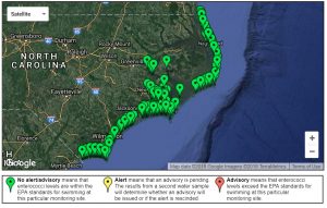
Each colored pin on the map represents a site where the state is monitoring the water.
Use the controls on the left side of the map to zoom in on Pleasure Island. The map will look more like this:

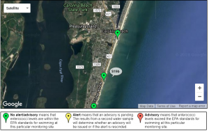
If you continue to zoom in, you will isolate site S19B, which is located just south of Alabama Ave., not far from the Kure Beach Village gazebo. Click on the green pin and an informational bubble will appear similar to this:

The state tests to determine if the bacteria count measured in the water is within EPA guidelines. A green pin on the map indicates safe levels of bacteria. Yellow means that there has been a single test showing unsafe levels. Red warns that two tests in a row have found unsafe levels of bacteria at that particular site.
You can also click the link that says View Sampling Data. This will show the test results for that particular site since the beginning of the year.